
Convert 3D Point Clouds to Compelling Animations
![]()
FARO 3D Zone Software
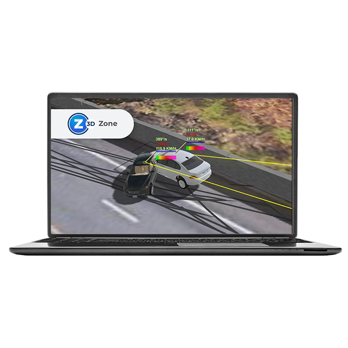
Don't Just Document, Predict: FARO Zone 3D - Revolutionizing Forensic Analysis
Unraveling the Truth with Precision
When seconds count and evidence whispers untold stories, investigators need a partner, not just software. FARO Zone 3D Pro and Expert rise to the challenge, transforming complex scenes into crystal-clear narratives.
Whether it's a crash reconstruction, a crime scene investigation, or a fiery inferno's aftermath, Zone 3D meticulously captures every detail. Import data from laser scanners, drones, even smartphones, and seamlessly weave them into precise 2D and 3D diagrams. Animate trajectories, visualize bullet paths, and reconstruct collisions with pinpoint accuracy.
Your Pocket-Sized
Scene Scanner
No expensive equipment? No problem. The revolutionizing FotoPoints feature in Zone 3D Expert empowers you to transform everyday photos and videos into detailed 3D point clouds.
Ditch the third-party software and cloud processing hassles. Simply point your smartphone or drone at the scene, and FotoPoints does the rest. Instantly generate high-resolution orthographic images, perfect for measurements, annotations, and diagram creation.
Capture evidence anywhere, anytime, with the power of FotoPoints in your pocket.
Collision Forensics
Made Easy
Accidents happen in a blink, but their repercussions linger. With MassZone Collision Prediction, Zone 3D Expert takes forensic analysis to the next level.
Forget painstaking data entry. Simply input vehicle parameters and witness accounts, and let MassZone automatically recreate the collision with stunning accuracy.
Witness the impact unfold, analyse tire marks and vehicle damage, and build a watertight case in record time.


Unleash the Full Potential of the Orbis Mobile Laser Scanner
Business Value of the Orbis Mobile Laser Scanner
Simplify your scanning process
Just a click and a walk is all it takes to collect valuable data effortlessly. Designed for usability, Orbis streamlines surveying tasks for everyone, no matter the industry. Now you can capture data in places you never thought possible before. Discover the ease and efficiency of Orbis.
Unlock Powerful Insights
Experience the next level of data capture with our cutting-edge 3D technology. Elevate your understanding and gain valuable insights into your projects. Stay ahead of the curve in dynamic industries like construction, by capturing data more frequently and comprehensively. Our user-friendly and portable solution seamlessly integrates into any job site, providing a constant stream of fresh insights to transform your decision-making and collaboration. Revolutionize your projects and deliverables with our synergy-driven approach.
Peace of Mind One-Year Warranty
At FARO, quality is at the core of everything we do. We meticulously design, build, and test our products to ensure top-notch performance. That's why we confidently offer a one-year warranty with every purchase, because we believe in the durability and reliability of our hardware. But that's not all - we also provide affordable extended service plans, so you can protect your investment and avoid any unexpected expenses. Trust in our commitment to your satisfaction and enjoy the peace of mind you deserve.
Ultimate All-in-one Mapping Solution
Compatible with a range of accessories including a monopod, car mount, backpack, and cradle, this versatile device is perfect for capturing every kind of terrain, from stationary scans to expansive landscapes. From mineshaft exploration to outdoor adventures, the Orbis has you covered. Discover the endless possibilities and take your mapping to the next level.
FARO Obris Mobile Performance
Hybrid Reality Capture with FLASH Technology
Upgrade your mobile scanning capabilities with Hybrid Reality Capture, featuring our cutting-edge FLASH Technology. Experience unprecedented mobile and stationary scanning accuracy and detail with Orbis, the ultimate scanning solution. Achieve unmatched speed, data clarity, and precision all in one comprehensive package. Elevate your scanning game to the next level with FARO's Hybrid Reality Capture and FLASH Technology.
Experience the Speed of the Future
Orbis Mobile Scanning Technology
Unleash the power of rapid data capture with Orbis. Our cutting-edge mobile scanning technology revolutionizes project timelines, allowing you to acquire accurate spatial data at an unprecedented pace. Say goodbye to traditional laser scanning and hello to Orbis, the solution that will propel you ahead in today's fast-paced world.
GeoSLAM's Cutting-Edge SLAM Algorithm
Unlock unparalleled results with GeoSLAM's revolutionary SLAM algorithm. Trusted by top professionals worldwide, our algorithm, powering the exceptional Orbis, has stood the test of time in the toughest of conditions for over a decade. Continual innovation fueled by valuable customer feedback ensures our algorithm consistently exceeds expectations, transforming projects across various industries.
FARO Orbis Mobile Features
Effortless Scanning with Orbis
Weighing only 3.6kg, with the datalogger and battery included, Orbis is the ultimate tool for swift and hassle-free scanning of vast areas. No more cumbersome setups required!
Unparalleled Accuracy
Achieve a precision of 5mm with mobile scans and an impressive 2mm with stationary Flash scanning. Orbis is the top choice for those seeking ultimate accuracy in mobile scanning solutions.
Indoor and Outdoor Mapping
Whether you're working inside or exploring the great outdoors, Orbis has got you covered with a remarkable range of up to 120 meters. Say goodbye to limitations and embrace limitless possibilities with Orbis.
Accurately Map the Toughest Environments
Experience the unrivalled capabilities of Orbis - a cutting-edge solution crafted to conquer the most challenging environments. From underground mines to dense forests and construction sites, Orbis seamlessly maps any environment with precision and ease.
AEC, Mining and Geospatial Applications
Maximize Mining Efficiency and Safety
Put safety first. Orbis reduces risk to human life by minimising exposure to hazardous environments. With Orbis, you can confidently navigate your mine while safeguarding your team.
Capture stockpile volumetric calculations, track production progress, analyze convergence, and inspect vertical shafts with ease. Our impressive rate of data capture and range capabilities empower you to make informed decisions and optimise your mining operations.
Unlock the potential of your mine with Orbis. Experience unbeatable efficiency, maximize returns on your investment, and pave the way for a successful mining future.
Streamline AEC Data Capture and Collaboration with Orbis
Stay ahead of the competition with our cutting-edge solution for AEC projects. Orbis delivers fast and precise data capture, enabling you to track progress effortlessly on a monthly, weekly, or daily basis. Say goodbye to disruptions on the job site and hello to seamless analysis.
The Ultimate Data Capture Solution
Ideal for geospatial workflows and various applications, Orbis offers unmatched flexibility and precision. No matter the task at hand, whether it's dynamic scanning or meticulous Flash scans, our versatile solution delivers outstanding results every time.
Don't settle for anything less than the best. Choose Orbis and experience the synergy of speed, accuracy, and convenience.
Say hello to a new era of data capture!

Performance Specifications
| Performance Specifications | ||||||||
| Range | 120m | |||||||
| Points Per Second | 640,000 | |||||||
| Field of View | 360° x 290° | |||||||
| No. of LIDAR channels | 32 | |||||||
| Camera | Full 360° image of 8M pixels captured every second | |||||||
| Mobile Scanning | ||||||||
| Precision1 | 5mm | |||||||
| Trajectory & Mapping | Robust SLAM powered by GeoSLAM technology | |||||||
| Settings | Automatic Standard and Preset Processing Environments | |||||||
| Stationary Flash Scanning | ||||||||
| Precision1 | 2mm | |||||||
| Duration | 15 sec. including color | |||||||
| Resolution | 19M points (13mm @ 10m) | |||||||
| Registration | Real-Time and Fully Automatic with GeoSLAM technology | |||||||
| General Features | |||||||||||
| Environment | Indoor and Outdoor | ||||||||||
| Laser Class2 | Class 1, Eye Safe | ||||||||||
| Weight | Scanner: 2.10kg, Datalogger: 0.95kg, Battery: 0.55kg | ||||||||||
| Protection Class | IP 54 | ||||||||||
| Transport Case Dimensions | 500mm x 625mm x 250mm | ||||||||||
| Operating Temperature | 0° to +40°C | ||||||||||
| Manufacturer Warranty | 1 Year | ||||||||||
| Data | Point clouds with Intensity and Color, 360° Images, Trajectory | ||||||||||
| Raw Mobile Data Size | 350MB/min uncompressed | ||||||||||
| Flash Scan Data Size | 125MB | ||||||||||
| Desktop Processing | FARO Connect for Mobile and Flash Scans, FARO Scene for Advanced Registration | ||||||||||
| Cloud Processing | Fully automated with FARO Sphere XG | ||||||||||
| Output | Mobile scan: E57, LAS, LAZ, PLY, TXT Flash scan: E57 |
||||||||||
1 Given as one sigma | 2 Under IEC EN60825-1 | Specifications are subject to change without prior notice
Related Products
Sphere XG
FARO Sphere XG is a digital Reality Platform that provides users with a centralised, collaborative experience across the reality capture applications and customer support tools through a secure, single-point sign-on process (SSO).
Scene
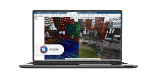
FARO SCENE Software is where data processing and scan registration happens. With 3D SCENE Software, users can create stunning 3D visualizations of real-world objects and environments and export that data in various formats.
Connect
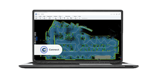
Experience seamless productivity with FARO Connect, the cutting-edge LiDAR software exclusively designed for data captured from the advanced FARO Orbis mobile scanner. Elevate your efficiency and unlock new possibilities like never before.